
It may not have a name but a tropical disturbance will bring heavy rain this week
Heavy rain on the way (again)
Jun 4, 2019, 10:40 am
So here we are a whole four days into hurricane season and we are already talking about a tropical thing in the Gulf of Mexico. The blob currently designated as Invest 91L (an Invest is an area of interest the National Hurrican Center is watching for potential development) at one point looked as though it had a chance to develop into some kind of organized system now looks like it will remain an amorphous blob. However don't let its nameless status fool you. 91L is going to be a player in our weather as it will bring heavy rain over the course of the next couple of days. So what is the story? Lets dive in...
WHY: A large area of low pressure has been in the southern Gulf of Mexico for a couple of days now slowly drifting toward the east Mexican coast far south of Brownsville. While at one time it looked like this system could develop enough to acquire the characteristics of a minimal named tropical storm (minimum winds of 39 MPH) it now appears time is running out for that to happen. To use a analogy - the system has been like a car sputtering its engine over the past few days never really able to get going. Now that it is approaching the coast it has run out of roadway to get the wheels turning. However, even though the engine may not be running very well there is still a ton of fuel (moisture) in the tank. That fuel is leaking out and being pushed our way. While this may not be the most scientifically accurate analogy I think it sums up the situation in a mostly understandable way.
Over the next two days a couple of features in the upper atmosphere, one to our west and one to out east, are going to create a windfield that will funnel the moisture from 91L into Southeast Texas.
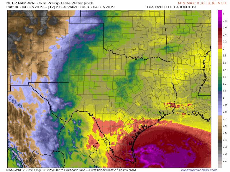 Model showing movement of atmospheric moisture (called precipitable water moving into Southeast Texas between today and late Wednesday night. Redder colors indicate higher moisture.Weathermodels.com
The area of low pressure that is 91L combined with an area of low pressure off to our northwest will help provide the lift necessary to turn all of this moisture into rain. With that being the set up here is what you can expect.
WHEN: Rain showers could start as soon as this evening or late tonight and will continue throughout the day on Wednesday and probably into Wednesday night. By mid day Thursday things should be quieting down. Timing of the heaviest rains is going to be difficult to pin down but right now it looks like Wednesday morning is the currently the favored time (unfortunately for rush-hour), however this could easily change.
WHERE: All of the area will probably see rain from this event but amounts will be less further inland and increase as you get closer to the coast. These tropical air masses are notorious for dropping high accumulation bulls-eyes in isolated spots but those exact locations are nearly impossible to predict. If I were placing a wager I'd say the heaviest rain from this event will be most likely somewhere close to and south of the HWY 59 corridor.
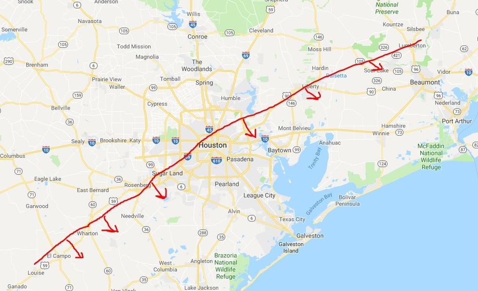 Heaviest rain probably somewhere along and south of the red line
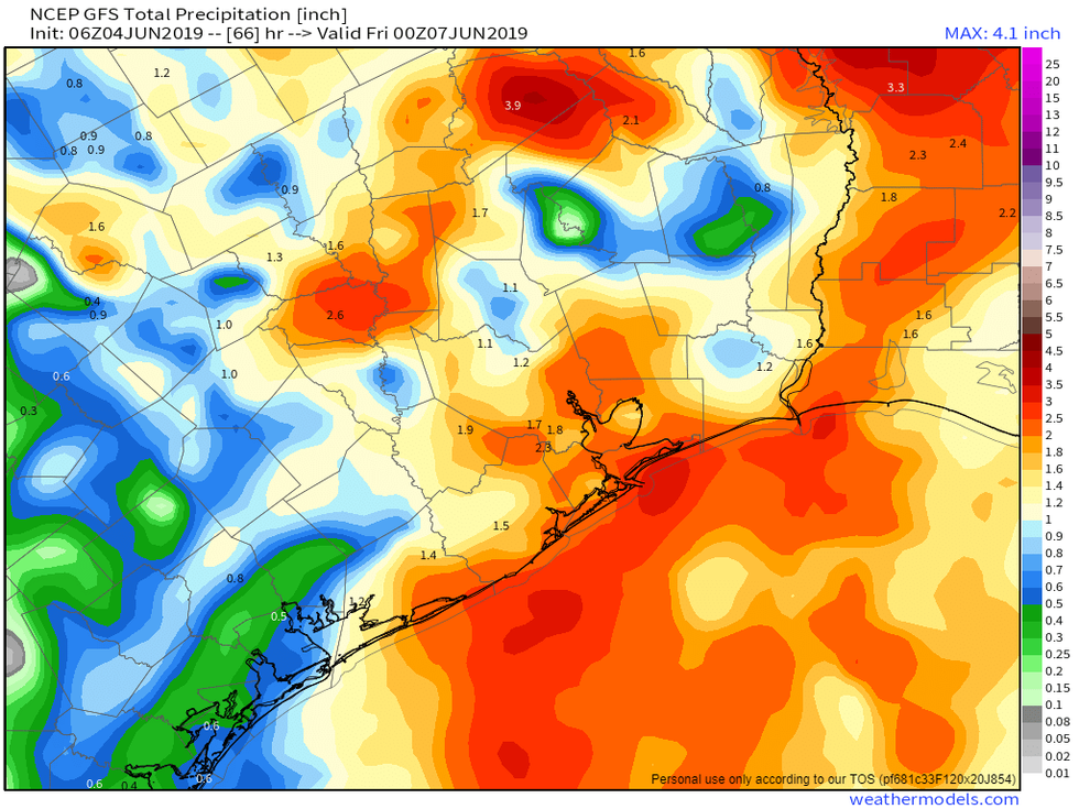
HOW MUCH: There has been some disagreement among the various computer models about how much rain we can expect out of this system. Some are showing as little as 2-3 inches while others are showing 5-7 inches with scattered bulls-eyes of 9-12 inches.
 GFS (American) model of foretasted rainfall totals through Thursday evening.Weathermodels.com
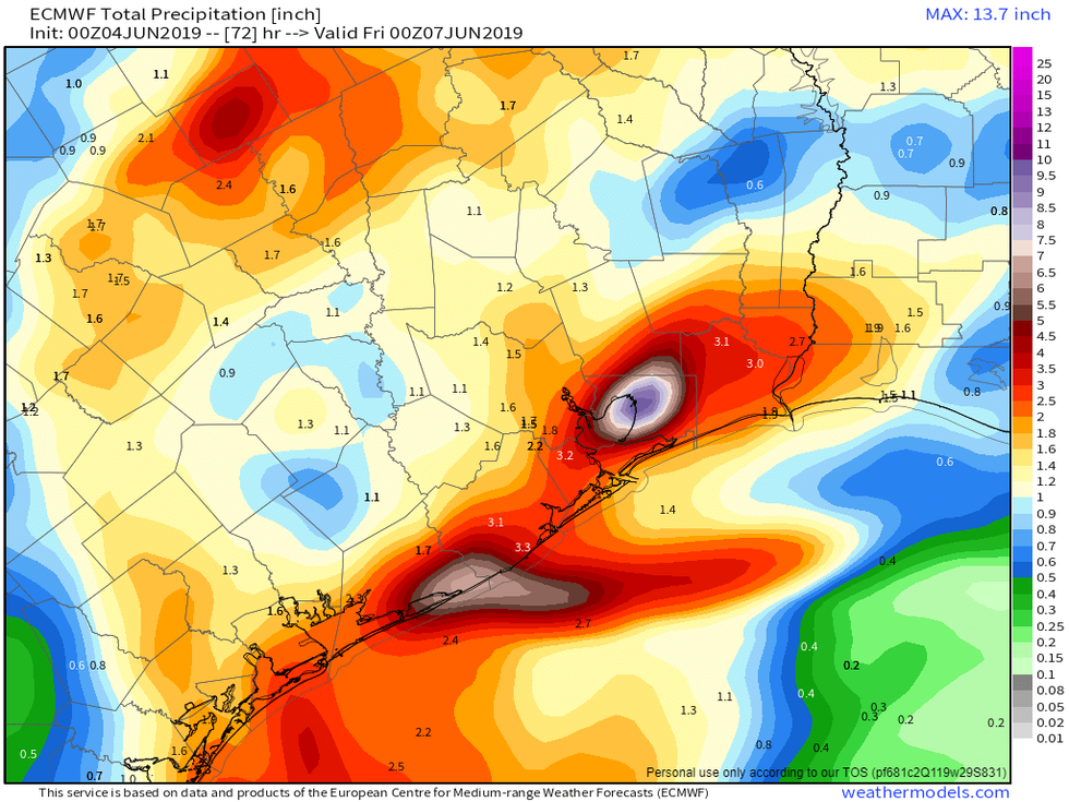 European model showing foretasted rainfall totals though Thursday evening.Weathermodels.com
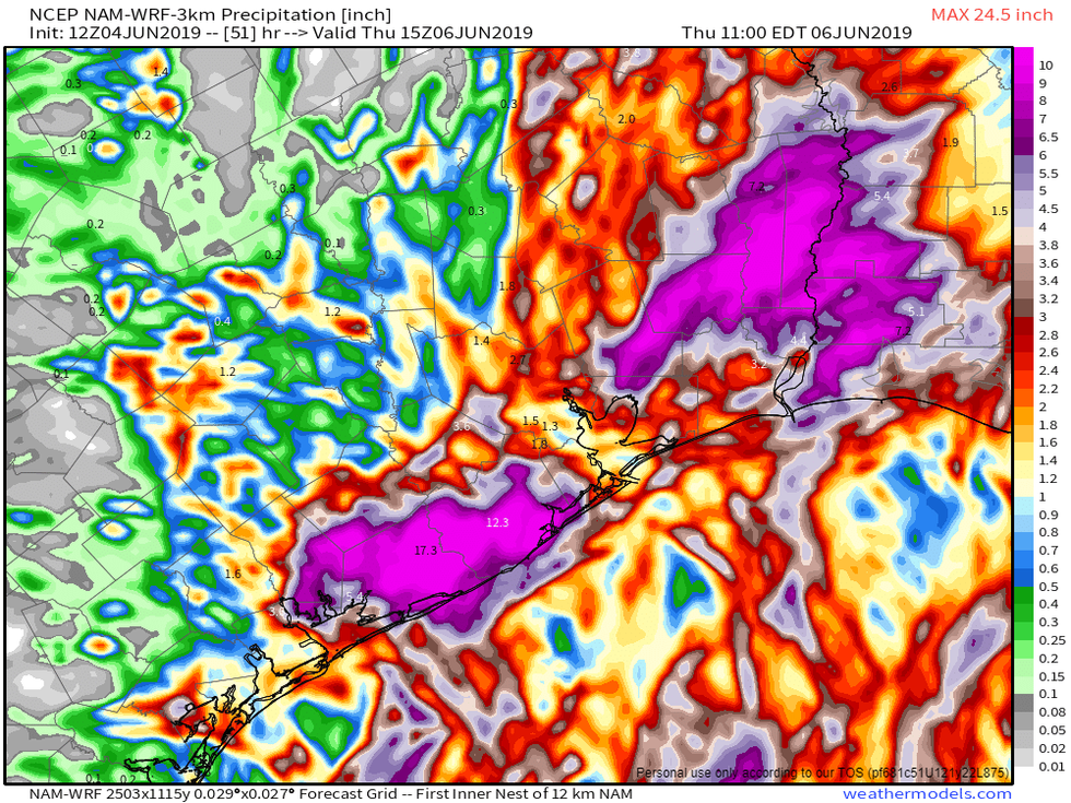 NAM (North American Model) showing foretasted rainfall totals through mid-day ThursdayWeathermodels.com
Usually when there is a big split in the models we like to hedge and forecast somewhere in the middle. However with a very moist tropical air mass like the one coming in, my personal thought is that the totals will be a little higher than what the middle ground would suggest. In my estimation 4-6 inches seems like a good guess south of 59 with 2-3 inches north of 59. But if you happen to get caught under a particularly heavy storm those totals could well be exceeded. While rain totals are the sexy stat around here these days, this is going to be another event where the rainfall rate is going to be the real issue. Rain will not be constantly falling for 36 hours, instead there will bands of rain that come through with breaks in between. However within those bands we may see multiple inches fall in a short period of time. As a general rule most of our streets are designed to handle 1-2 inches of rain per hour. However this system has the potential to produce rainfall rates of 3-4 inches per hour. Again not everyone will see that kind of rain dump, but someone probably will, we just cant say who exactly. With those kind of rainfall rates street flooding could be come an issue. I do not anticipate this being a major damaging flood event but I think street flooding is possible if not likely in some areas so you should just be mindful of that fact and plan accordingly, especially if the timing happens to coincide with rush hour. I know "Turn around don't drown" has become a tired phrase around here, but seriously don't drive through water, more often than not it is higher than you think it is.
I will be back with an update tomorrow morning. In the mean time feel free to find me on Twitter @stephenuzick for more weather stuff or if you have any questions.
