
Tropical system could bring flooding rain to our area
WeatherMap: Another heavy rain event is here
Sep 17, 2019, 9:20 am
When it comes to Houston weather nothing is gradual. Over the past couple of months we have slipped into a drought after a very wet past couple of years. Well this week that changes as Houston goes from drought to potentially flood in just a couple of days. In anticipation of this event the National Weather Service has issued a Flash Flood Watch from 1 PM today until 1 PM Wednesday, though in all likelihood this will be extended through Thursday.
The Set Up: An area of low pressure has set up in the Gulf of Mexico south east of Matagorda and will be sending extremely high levels of atmospheric moisture into our area over the next couple of days. The system could organize enough to become a tropical depression or tropical storm before moving in around Matagorda tonight, but that will be of little significance. The problem will be that this system will be moving very slowly between now and Thursday putting us under the gun for heavy rain.
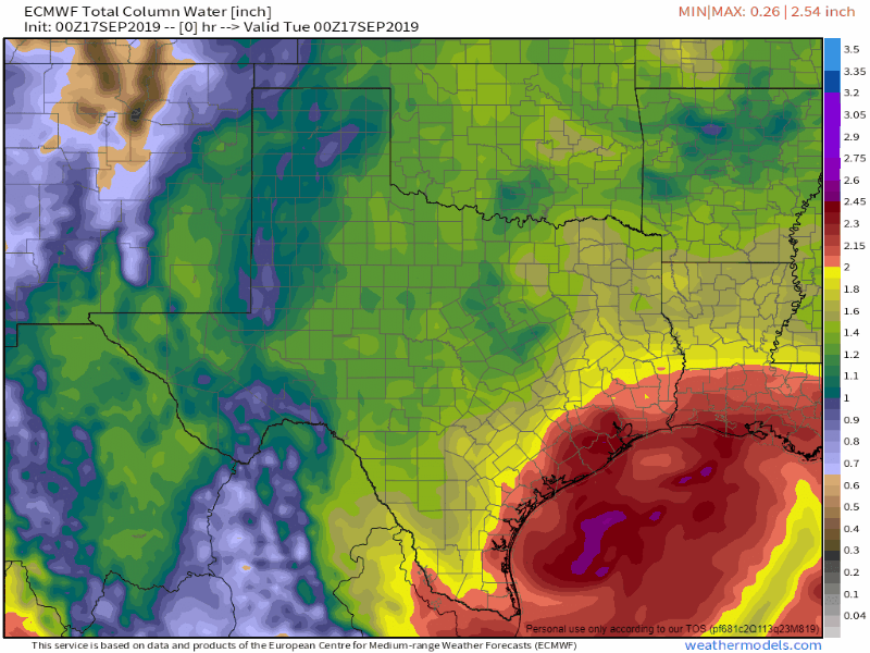 Very high atmospheric moisture levels moving into the area over the next 72 hoursWeathermodels.com
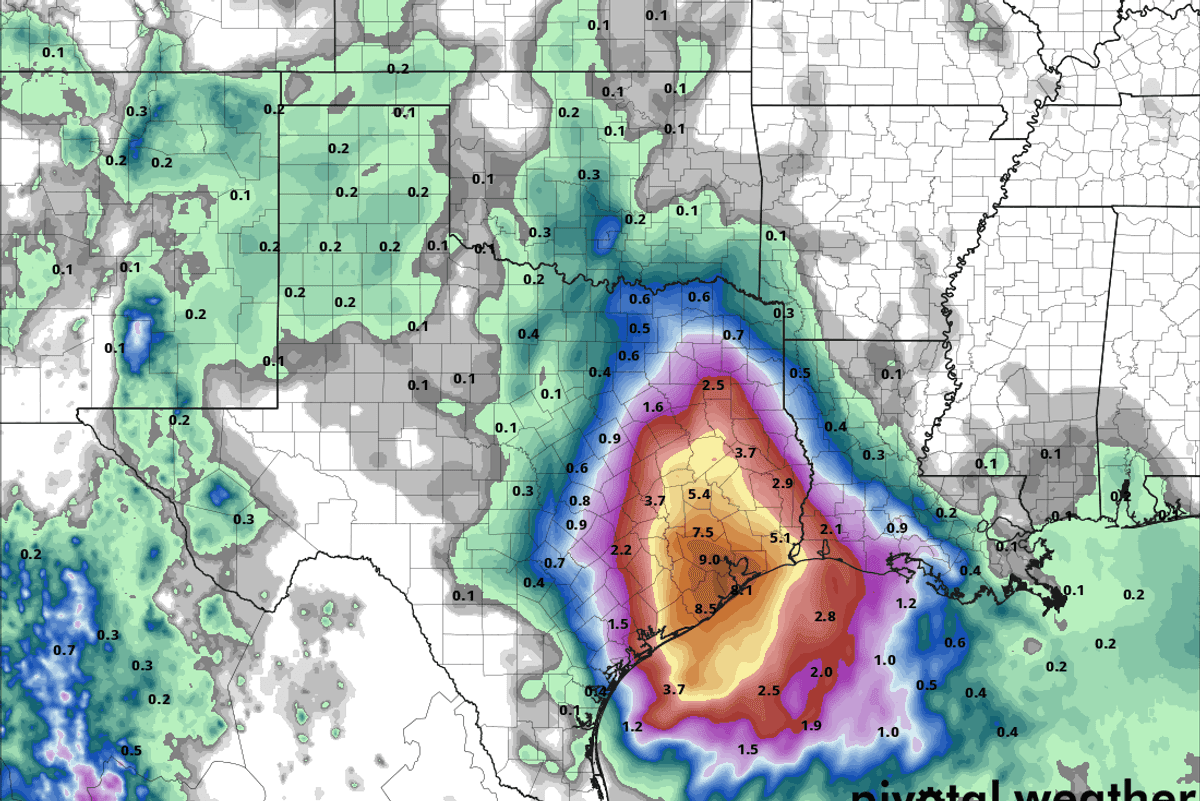
How Much Rain: Computer models seem to be coming into better agreement that between Matagorda and Beaumont widespread amount of 5-8 inches of rain will be possible. The fly in the ointment is that there will likely be isolated jackpot zones that could see 10-15 inches of rain. Now if all of this rain were to be evenly disbursed over the next 72 hours there probably wouldn't be major impacts as the ground has been so dry. However, that is not going to happen. As is often the case with these tropical air masses, rain will come in very heavy bursts that can dump 3, 4, or 5 inches of rain in very short order. Right now street flooding in usual trouble spot looks quite possible, but more significant impacts, while not certain right now, are not off the table.
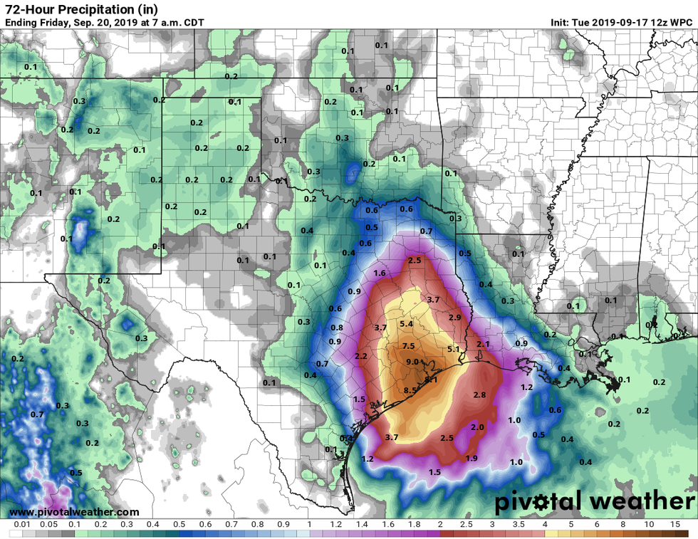 Best reasonable guess at rainfall totals through Friday morning. There could be spots that get higher amounts.Pivotal Weather
When: Rain is already coming down this morning which will serve help saturate the ground. The rain today shouldn't be too much of an issue. While there could be some heavy showers at times it should remain manageable. The time frame for more significant impacts looks to be between tomorrow morning and Thursday afternoon. During this time waves of heavy rain will move through piling up good accumulations in short periods of time. Depending on where the center of this system tracks Wednesday night into Thursday morning may need to be watched for what is called a core rain event. This is when very heavy rainfall concentrates around the center of low pressure at night due in part to temperature changed in the atmosphere after the sun goes down. This isn't a guarantee but is something that I am watching out for.
Where: This is the million dollar question. There is a good idea of the broad area of concern which I have highlighted in the map below.
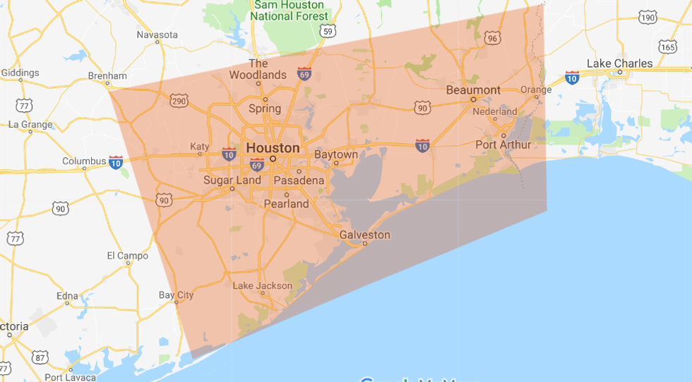 Area of concern for heavy rain highlighted in orange box.
However, it is nearly impossible to forecast exactly which neighborhoods will see the heaviest rains. Unfortunately these events involve a good bit of "now-casting" where we have to watch how things develop to know which spots may be hit hardest. The key in these situations is to prepare as though you may be in one of the bulls-eyes and hope that you aren't. Any one location's odds of getting 15+ inches of rain from this system is low, but no where within the area of concern has a 0% chance.
The frustrating part of these storms is that there is high variability in what impacts will be. I am confident everyone will get at least a healthy amount of rain which should at the very least be beneficial for our parched yards. I am also confident that someone will get too much rain over the next 72 hours, but again, I just can't tell you who it will be. Right now the best thing to do is to be prepared for heavy rain and possible flooding impacts between late tonight and Thursday afternoon. I will be back later tonight or tomorrow morning with an update.
As always you can find me on Twitter @stephenuzick
