
Another heavy rain event is headed our way. I break it down for you here.
What you need to know about our heavy rain forecast
May 9, 2019, 12:04 pm
Another heavy rain event is headed our way. I break it down for you here.
So here we are, another holiday weekend (Mothers Day in case you forgot), staring yet another heavy rain event in the face. Springtime heavy rain events in this area are notoriously difficult to forecast and this week's storm is no different. So while I can't tell you exactly where and how much it will rain in any given spot I do want to take this opportunity to explain the threat in a manner that is hopefully easy to understand.
This afternoon a front is going to drop down through the state and stall over our area. This front will serve as a focusing mechanism for storms over the next few days. It will be both a source of the lift that is needed to form storms as well as a track for atmospheric disturbances – triggering mechanisms – traversing the area. If you walked outside today you undoubtedly noticed the absurd humidity. This is a result of copious amount of moisture being pumped in off the Gulf which is nothing but storm fuel. Beginning late Thursday and continuing through Saturday evening a number of disturbances will be riding along the stalled front triggering storms like pulses of electricity running down a wire, that also happens to have a bottle of lighter fluid pointed at it.
Once storms form they may be in no hurry to move, or may keep building on themselves causing some unlucky spots to be pounded for hours. This is where the flooding issue sets in. Another compounding factor will be that at times the airflow in the upper atmosphere (part of the jet stream) will split off in different directions over the area. This will provide an additional source of lift for the storms and essentially act as an exhaust fan helping to fan the flames. This will only serve to increase the rainmaking ability of the storms.
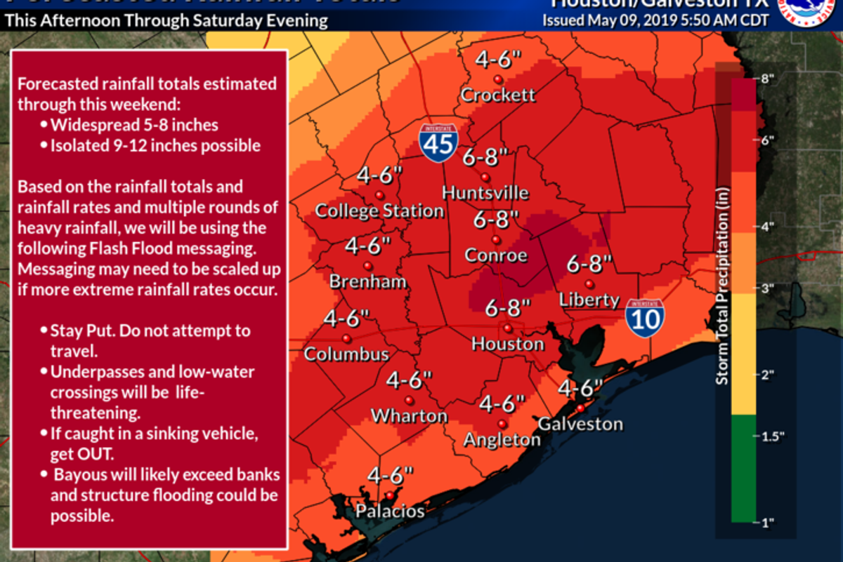
The general consensus is that this event will begin late this afternoon or this evening and continue through Saturday evening. It will not rain the entire time but waves of heavy rain and storms will be possible any time during that time frame as those atmospheric disturbances make their way across the area. The best advice would be to stay alert especially if you have plans to be out during that time, especially at night.
By now I am sure you have seen on the local weather reports that anywhere between 3 to 5 inches will be common with some spots getting up to 12 inches. While it is true that some spots may indeed only see a couple of inches of rain in this event it is impossible at this time to determine where the rain bulls-eyes will be. Speaking of those bulls-eyes – these type of set ups can very easily over-produce so while the "official forecast" right now calls for high spots of 12 inches I really wouldn't be shocked if a couple of places picked up 15 or maybe even 20 inches of rain before this is all said and done.
The real issue in these situations is really rainfall rates, or how much rain falls per hour. For the most part our streets and drainage systems are designed to handle about 1 to 1.5 inches per hour. However, as we saw on Tuesday these types of storms in an absolutely juiced up atmosphere can produce rainfall rates that far exceed that, sometimes pushing 4 or 5 inches per hour. It is these high rainfall rates that will produce the flooding issues that we see. As I mentioned above there will be breaks in the rain over the next few days, the problem is going to be that most of the 10 inches someone gets may all fall within a 2 or 3 hour span.
Unfortunately this is simply impossible to determine right now. Before you get all cranky on meteorologists no being able to get things right let me explain why. Many of the atmospheric features that determine exactly where storms form and produce heavy rain are so small that they cannot be seen until a few hours out, if that. The computer models that are typically used to aid in creating a forecast can only project conditions down to a certain area (their resolution). The models that forecast on a global basis can "see" things down to 6-10 miles wile some higher resolution models can "see" things down to just a couple of miles. So while these models are helpful in showing us the overall set up is ripe for heavy rain they are unable to accurately pick up on boundaries or other triggering mechanisms that may below their resolution. In addition to that, once storms form they create their own environments, often sending out additional boundaries which trigger more storms nearby. This chain reaction effect is also nearly impossible to predict with accuracy. While the science of meteorology is light years ahead of where it was even 10 -15 years ago it still is not perfect.
The key here is to prepare as though you will find yourself in one of these rain bulls-eyes and hope for the best. These areas will be relatively small and probably spread out across the area but it is just impossible to tell right now which neighborhoods will be the ones to get them.
I know heavy rain events cause a lot of anxiety and stress in our post Harvey world, but I want to assure you that there is no indication that this event will be another Harvey. Yes there will likely be street flooding and maybe some structure flooding in places but this will not be a widespread catastrophic event. This type of system is part of the reality of living on the Gulf Coast in a highly urban area. Heavy rainfalls are a fact of life and the best we can do is arm ourselves with the knowledge necessary to be prepared and use our best judgment to stay safe.
P.S. If you do not already, I would highly encourage you to follow the Houston National Weather Service office on whatever social media platforms you like to use. They are an invaluable source of information and are the ones who issue any warnings that may be necessary.

Oswald Peraza hit a two-run single in the ninth inning to help the Los Angeles Angels snap a three-game losing skid by beating the Houston Astros 4-1 on Saturday night.
Peraza entered the game as a defensive replacement in the seventh inning and hit a bases-loaded fly ball to deep right field that eluded the outstretched glove of Cam Smith. It was the fourth straight hit off Astros closer Bryan Abreu (3-4), who had not allowed a run in his previous 12 appearances.
The Angels third run of the ninth inning scored when Mike Trout walked with the bases loaded.
Kyle Hendricks allowed one run while scattering seven hits over six innings. He held the Astros to 1 for 8 with runners in scoring position, the one hit coming on Jesús Sánchez’s third-inning infield single that scored Jeremy Peña.
Reid Detmers worked around a leadoff walk to keep the Astros scoreless in the seventh, and José Fermin (3-2) retired the side in order in the eighth before Kenley Jansen worked a scoreless ninth to earn his 24th save.
Houston’s Spencer Arrighetti struck out a season-high eight batters over 6 1/3 innings. The only hit he allowed was Zach Neto’s third-inning solo home run.
Yordan Alvarez had two hits for the Astros, who remained three games ahead of Seattle for first place in the AL West.
Peraza’s two-run single to deep right field that broke a 1-1 tie in the ninth.
Opponents were 5 for 44 against Abreu in August before he allowed four straight hits in the ninth.
Astros RHP Hunter Brown (10-6, 2.37 ERA) faces RHP José Soriano (9-9, 3.85) when the series continues Sunday.